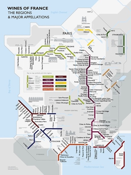
Traveling Along France's Metro Wine Map

Want to visit the vast French wine country?
To start off, how about taking the "A" train to Lyon, then switching to the "L" line at Vienne to Chateauneuf-du-Pape? Or go from Nantes to Orleans, passing through the wine regions of the Loir Valley?
Intrigued by the various groupings and towns within each wine region in France — say, those of Bordeaux and Burgundy — Dr. David Gissen, an architectural historian and imaginative wine buff, decided to collect each one together as if they were train stops on the Paris Metro or NYC's subway lines.
For example, jump on the Bordeaux line at Sauternes and ride north to Bordeaux city, then transfer to the Right Bank line to St. Emilion. Or, take the Left Bank route through Margaux, Moulis, Listrac-Medoc, St. Julien, and Paulliac, to St. Estephe and then, finally, to Medoc at the end of the line next to the Atlantic.
But don't throw away your GPS just yet. While the Metro Wine Map of France is probably unparalleled as far as being a tool to help learn the relative locations of wine regions without all the clutter — not to mention it makes a nice wall graphic — it's of no practical navigation value.
Gissen's map is available online for $24.95 through the British-based De Long Company, which has just released it along with a conventional (and very handy, up-to-date) map of Long Island's wineries for $29.95.